 |
The Port and the airport operate normally.
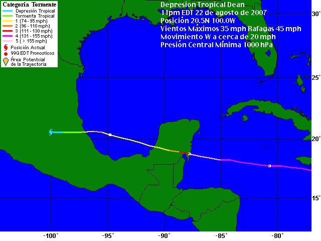
“Dean” changes its path
The eye would enter early tomorrow near Chetumal and would exit around the Seybaplaya area. The new trajectory affects mainly the south of the Yucatan Peninsula.
An abrupt change in the path of hurricane “Dean” on its way to the Yucatan Peninsula modified yesterday the forecasts and obliged to make adjustments to the preventions strategies..
After hitting Jamaica, Dean was advancing in the first minutes of today towards the Yucatan Peninsula as a category 4 hurricane, at a speed of 32 Km per hour and maximum sustained winds of 240 km per hour. Meteorologists consider that it would intensify its strenght in the next few hours and when it reaches Quintana Roo tonight would be Category 5.
In accordance to the new projections, the hurricane would enter the Peninsula early tomorrow. The eye would touch land at 5 hours near Chetumal – much more to the south than it was expected – with maximum sustained winds in its center of 260 Km per hour and gusts of 315 Kn per hour. It would loose strenght as it advences on peninsular terrotory. At 5 pm it would exit to the Gulf of Mexico thru Seybaplaya, Campeche with maximum sustained winds of 150 Km per hour, as a category 1 hurricane.
The eye of “Dean” would be in the Peninsula around 12 hours, but its effects, which vary in their intensity in accordance to the eye’s proximity, would be felt for 23 hours. The 195 Km per hour winds would extend for 165 Km from the center, and the 65 Km per hour winds up to 335 Km.
The CFE states that, as it moves on the land, “DEan” would bring rains that would vary from strong to intense, in Quintana Roo, Yucatan and Campeche, “with values over 250mm, that can create flods and landslides, plus a high surge and strong winds, mainly in the coastal area”.
The erratic dispklacement of the hurricane keeps the three peninsular states very concerned. The path was still descending last night, lightly to the south, so the risk of a direct impact over Cancun, Merida and the north coast was decreasing, and it was increasing for the maya region of Quintana Roo, the south of Yucatan and the central area of Campeche.
After the possible path was known, the pervention plans were modified to include the villages that were not initially considered.
In Yucatan, yesterday began the movements for transporting to a safer place all the inhabitants of the south and coastal areas.
The Civil Defense of Yucatan director, Mr. Ernesto Martinez Ordaz, reported that trucks were send to the endangered areas. “An approximate calculation would be of evicting today up to 16,000 people" he said.
At the web page www.nhc.noaa.gov/ you can see the next 5 days forecast, and it's quite good. We also have one in Yucatan: www.yucatan.com.mx
Dean changes its path and as we can see in the last report of the inferior not would come out thru Seybaplaya, here in Progreso we will have a lot of rain tomorrow and winds up to 70 -80 Km per hour, nothing to be scared about. Today the day began perfectly: Sun, no winds and a totally clear sky.
The port and the airport would operate normally.
|